本文為英文版的機器翻譯版本,如內容有任何歧義或不一致之處,概以英文版為準。
如何將路由新增至靜態映射
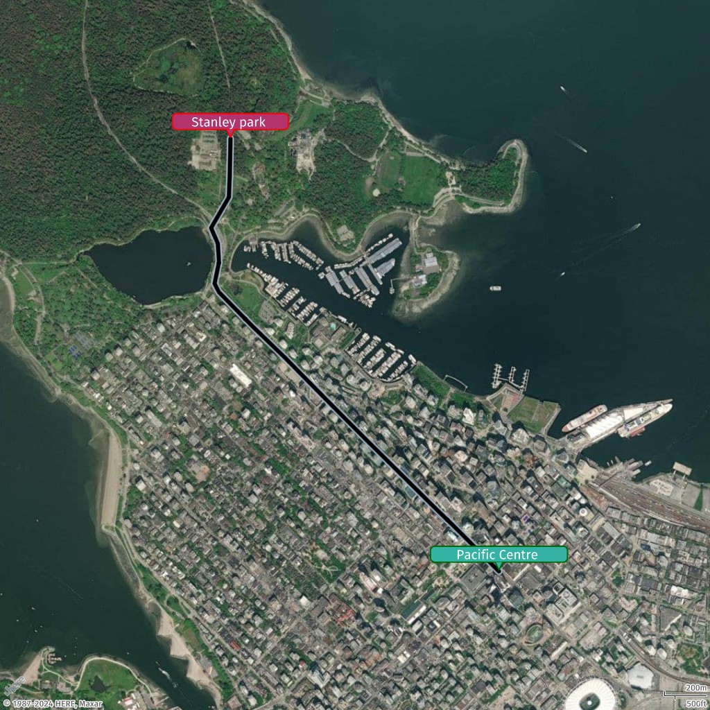
在本主題中,您將了解如何使用 Amazon Location Service 將路由新增至靜態地圖。您將完成使用 CalculateRoutes API 取得路由的步驟,然後使用 GeoJSON 和點和線的自訂樣式,將其視覺化在靜態地圖上。
新增路由的步驟
-
從
CalculateRoutesAPI 取得路由。移除位於同一直線上的座標,以最佳化 LineString,防止查詢字串達到其限制。 -
根據最佳化的座標集建立 GeoJSON 物件。
-
取得 LineString 的第一點和最後一點,並新增點幾何以標記開始和結束位置。
-
根據您的業務需求來調整點和 LineString 的樣式,調整顏色、大小和標籤等屬性。
使用精簡樣式新增路由
在此範例中,您會將具有起點和終點的路由新增至 中建立的行如何將線條新增至靜態地圖。將使用自訂樣式定義路由,包括開始和結束點的顏色、大小和標籤。
{
  "type": "FeatureCollection",
  "features": [
    {
      "type": "Feature",
      "geometry": {
        "type": "LineString",
        "coordinates": [
          [-123.11813, 49.28246],
          [-123.11967, 49.28347],
          [-123.12108, 49.28439],
          [-123.12216, 49.28507],
          [-123.12688, 49.28812],
          [-123.1292, 49.28964],
          [-123.13216, 49.2916],
          [-123.13424, 49.29291],
          [-123.13649, 49.2944],
          [-123.13678, 49.29477],
          [-123.13649, 49.29569],
          [-123.13657, 49.29649],
          [-123.13701, 49.29715],
          [-123.13584, 49.29847],
          [-123.13579, 49.29935],
          [-123.13576, 49.30018],
          [-123.13574, 49.30097]
        ]
      },
      "properties": {
        "color": "#000000",
        "width": "20m",
        "outline-color": "#a8b9cc",
        "outline-width": "2px"
      }
    },
    {
      "type": "Feature",
      "geometry": {
        "type": "Point",
        "coordinates": [-123.11813, 49.28246]
      },
      "properties": {
        "label": "Pacific Centre",
        "icon": "bubble",
        "size": "large",
        "color": "#34B3A4",
        "outline-color": "#006400",
        "text-color": "#FFFFFF"
      }
    },
    {
      "type": "Feature",
      "geometry": {
        "type": "Point",
        "coordinates": [-123.13574, 49.30097]
      },
      "properties": {
        "label": "Stanley Park",
        "icon": "bubble",
        "size": "large",
        "color": "#B3346D",
        "outline-color": "#FF0000",
        "text-color": "#FFFFFF"
      }
    }
  ]
}