Terjemahan disediakan oleh mesin penerjemah. Jika konten terjemahan yang diberikan bertentangan dengan versi bahasa Inggris aslinya, utamakan versi bahasa Inggris.
Akses pengumpulan data Sentinel-2 raster dan buat pekerjaan observasi bumi untuk melakukan segmentasi lahan
Python-based Tutorial ini menggunakan SDK for Python (Boto3) dan notebook Amazon Studio Classic. SageMaker Untuk menyelesaikan demo ini dengan sukses, pastikan Anda memiliki izin AWS Identity and Access Management (IAM) yang diperlukan untuk menggunakan SageMaker geospasial dan Studio Classic. SageMaker geospasial mengharuskan Anda memiliki pengguna, grup, atau peran yang dapat mengakses Studio Classic. Anda juga harus memiliki peran eksekusi SageMaker AI yang menentukan prinsip layanan SageMaker geospasial, sagemaker-geospatial.amazonaws.com dalam kebijakan kepercayaannya.
Untuk mempelajari lebih lanjut tentang persyaratan ini, lihat peran IAM SageMaker geospasial.
Tutorial ini menunjukkan cara menggunakan API SageMaker geospasial untuk menyelesaikan tugas-tugas berikut:
-
Temukan koleksi data raster yang tersedia dengan
list_raster_data_collections. -
Cari pengumpulan data raster tertentu dengan menggunakan
search_raster_data_collection. -
Buat pekerjaan pengamatan bumi (EOJ) dengan menggunakan
start_earth_observation_job.
Menggunakan list_raster_data_collections untuk menemukan koleksi data yang tersedia
SageMaker geospasial mendukung beberapa pengumpulan data raster. Untuk mempelajari lebih lanjut tentang pengumpulan data yang tersedia, lihatPengumpulan data.
Demo ini menggunakan data satelit yang dikumpulkan dari satelit Sentinel-2 Cloud-OptimizedGeoTIFF
Untuk mencari area minat (AOI), Anda memerlukan ARN yang terkait dengan data satelit Sentinel-2 . Untuk menemukan koleksi data yang tersedia dan ARN terkait di Anda Wilayah AWS, gunakan operasi list_raster_data_collections API.
Karena respons dapat diberi paginasi, Anda harus menggunakan get_paginator operasi untuk mengembalikan semua data yang relevan:
import boto3
import sagemaker
import sagemaker_geospatial_map
import json

## SageMaker Geospatial  is currently only avaialable in US-WEST-2
session = boto3.Session(region_name='us-west-2')
execution_role = sagemaker.get_execution_role()

## Creates a SageMaker Geospatial client instance
geospatial_client = session.client(service_name="sagemaker-geospatial")

# Creates a resusable Paginator for the list_raster_data_collections API operation
paginator = geospatial_client.get_paginator("list_raster_data_collections")

# Create a PageIterator from the paginator class
page_iterator = paginator.paginate()

# Use the iterator to iterate throught the results of list_raster_data_collections
results = []
for page in page_iterator:
    results.append(page['RasterDataCollectionSummaries'])

print(results)
Ini adalah contoh respons JSON dari operasi list_raster_data_collections API. Itu terpotong untuk menyertakan hanya pengumpulan data (Sentinel-2) yang digunakan dalam contoh kodenya. Untuk detail selengkapnya tentang pengumpulan data raster tertentu, gunakanget_raster_data_collection:
{
    "Arn": "arn:aws:sagemaker-geospatial:us-west-2:378778860802:raster-data-collection/public/nmqj48dcu3g7ayw8",
    "Description": "Sentinel-2a and Sentinel-2b imagery, processed to Level 2A (Surface Reflectance) and converted to Cloud-Optimized GeoTIFFs",
    "DescriptionPageUrl": "https://registry.opendata.aws/sentinel-2-l2a-cogs",
    "Name": "Sentinel 2 L2A COGs",
    "SupportedFilters": [
        {
            "Maximum": 100,
            "Minimum": 0,
            "Name": "EoCloudCover",
            "Type": "number"
        },
        {
            "Maximum": 90,
            "Minimum": 0,
            "Name": "ViewOffNadir",
            "Type": "number"
        },
        {
            "Name": "Platform",
            "Type": "string"
        }
    ],
    "Tags": {},
    "Type": "PUBLIC"
}
Setelah menjalankan contoh kode sebelumnya, Anda mendapatkan ARN dari pengumpulan data Sentinel-2 raster,. arn:aws:sagemaker-geospatial:us-west-2:378778860802:raster-data-collection/public/nmqj48dcu3g7ayw8 Di bagian selanjutnya, Anda dapat melakukan kueri pengumpulan Sentinel-2 data menggunakan search_raster_data_collection API.
Mencari Sentinel-2 pengumpulan data raster menggunakan search_raster_data_collection
Di bagian sebelumnya, Anda biasa mendapatkan ARN list_raster_data_collections untuk pengumpulan data. Sentinel-2 Sekarang Anda dapat menggunakan ARN itu untuk mencari pengumpulan data di area minat tertentu (AOI), rentang waktu, properti, dan pita UV yang tersedia.
Untuk memanggil search_raster_data_collection API, Anda harus meneruskan Python dic tionary ke RasterDataCollectionQuery parameter. Contoh ini menggunakanAreaOfInterest,TimeRangeFilter,PropertyFilters, danBandFilter. Untuk memudahkan, Anda dapat menentukan kamus Python menggunakan variabel search_rdc_query untuk menahan parameter permintaan pencarian:
search_rdc_query = { "AreaOfInterest": { "AreaOfInterestGeometry": { "PolygonGeometry": { "Coordinates": [ [ # coordinates are input as longitute followed by latitude[-114.529, 36.142],[-114.373, 36.142],[-114.373, 36.411],[-114.529, 36.411],[-114.529, 36.142], ] ] } } }, "TimeRangeFilter": { "StartTime":"2022-01-01T00:00:00Z", "EndTime":"2022-07-10T23:59:59Z"}, "PropertyFilters": { "Properties": [ { "Property": { "EoCloudCover": { "LowerBound": 0, "UpperBound": 1 } } } ], "LogicalOperator": "AND" }, "BandFilter": ["visual"] }
Dalam contoh ini, Anda menanyakan AreaOfInterest yang menyertakan Danau Meadvisual pita.
Setelah membuat parameter kueri, Anda dapat menggunakan search_raster_data_collection API untuk membuat permintaan.
Contoh kode berikut mengimplementasikan permintaan search_raster_data_collection API. API ini tidak mendukung pagination menggunakan get_paginator API. Untuk memastikan bahwa respons API lengkap telah dikumpulkan, sampel kode menggunakan while loop untuk memeriksa apakah NextToken ada. Contoh kode kemudian digunakan .extend() untuk menambahkan URL citra satelit dan metadata respons lainnya ke file. items_list
Untuk mempelajari selengkapnyasearch_raster_data_collection, lihat SearchRasterDataCollectiondi Referensi Amazon SageMaker AI API.
search_rdc_response = sm_geo_client.search_raster_data_collection(
    Arn='arn:aws:sagemaker-geospatial:us-west-2:378778860802:raster-data-collection/public/nmqj48dcu3g7ayw8',
    RasterDataCollectionQuery=search_rdc_query
)


## items_list is the response from the API request.
items_list = []

## Use the python .get() method to check that the 'NextToken' exists, if null returns None breaking the while loop
while search_rdc_response.get('NextToken'):
    items_list.extend(search_rdc_response['Items'])
    search_rdc_response = sm_geo_client.search_raster_data_collection(
        Arn='arn:aws:sagemaker-geospatial:us-west-2:378778860802:raster-data-collection/public/nmqj48dcu3g7ayw8',
        RasterDataCollectionQuery=search_rdc_query, NextToken=search_rdc_response['NextToken']
    )

## Print the number of observation return based on the query
print (len(items_list))
Berikut ini adalah respons JSON dari kueri Anda. Itu telah dipotong untuk kejelasan. Hanya yang "BandFilter": ["visual"] ditentukan dalam permintaan yang dikembalikan dalam pasangan Assets kunci-nilai:
{ 'Assets': { 'visual': { 'Href': 'https://sentinel-cogs.s3.us-west-2.amazonaws.com/sentinel-s2-l2a-cogs/15/T/UH/2022/6/S2A_15TUH_20220623_0_L2A/TCI.tif' } }, 'DateTime': datetime.datetime(2022, 6, 23, 17, 22, 5, 926000, tzinfo = tzlocal()), 'Geometry': { 'Coordinates': [ [[-114.529, 36.142],[-114.373, 36.142],[-114.373, 36.411],[-114.529, 36.411],[-114.529, 36.142], ] ], 'Type': 'Polygon' }, 'Id': 'S2A_15TUH_20220623_0_L2A', 'Properties': { 'EoCloudCover': 0.046519, 'Platform': 'sentinel-2a' } }
Sekarang setelah Anda memiliki hasil kueri, di bagian selanjutnya Anda dapat memvisualisasikan hasilnya dengan menggunakanmatplotlib. Ini untuk memverifikasi bahwa hasil berasal dari wilayah geografis yang benar.
Memvisualisasikan search_raster_data_collection Anda menggunakan matplotlib
search_raster_data_collection Anda menggunakan matplotlibSebelum Anda memulai pekerjaan pengamatan bumi (EOJ), Anda dapat memvisualisasikan hasil dari pertanyaan kami dengan. matplotlib Contoh kode berikut mengambil item pertama,items_list[0]["Assets"]["visual"]["Href"], dari items_list variabel yang dibuat dalam sampel kode sebelumnya dan mencetak gambar menggunakanmatplotlib.
# Visualize an example image.
import os
from urllib import request
import tifffile
import matplotlib.pyplot as plt

image_dir = "./images/lake_mead"
os.makedirs(image_dir, exist_ok=True)

image_dir = "./images/lake_mead"
os.makedirs(image_dir, exist_ok=True)

image_url = items_list[0]["Assets"]["visual"]["Href"]
img_id = image_url.split("/")[-2]
path_to_image = image_dir + "/" + img_id + "_TCI.tif"
response = request.urlretrieve(image_url, path_to_image)
print("Downloaded image: " + img_id)

tci = tifffile.imread(path_to_image)
plt.figure(figsize=(6, 6))
plt.imshow(tci)
plt.show()
Setelah memeriksa apakah hasilnya berada di wilayah geografis yang benar, Anda dapat memulai Earth Observation Job (EOJ) pada langkah berikutnya. Anda menggunakan EOJ untuk mengidentifikasi badan air dari citra satelit dengan menggunakan proses yang disebut segmentasi tanah.
Memulai pekerjaan pengamatan bumi (EOJ) yang melakukan segmentasi tanah pada serangkaian citra satelit
SageMaker geospasial menyediakan beberapa model pra-terlatih yang dapat Anda gunakan untuk memproses data geospasial dari pengumpulan data raster. Untuk mempelajari lebih lanjut tentang model pra-terlatih yang tersedia dan operasi kustom, lihatJenis Operasi.
Untuk menghitung perubahan luas permukaan air, Anda perlu mengidentifikasi piksel mana dalam gambar yang sesuai dengan air. Segmentasi tutupan lahan adalah model segmentasi semantik yang didukung oleh API. start_earth_observation_job Model segmentasi semantik mengaitkan label dengan setiap piksel di setiap gambar. Dalam hasilnya, setiap piksel diberi label yang didasarkan pada peta kelas untuk model. Berikut ini adalah peta kelas untuk model segmentasi lahan:
{
    0: "No_data",
    1: "Saturated_or_defective",
    2: "Dark_area_pixels",
    3: "Cloud_shadows",
    4: "Vegetation",
    5: "Not_vegetated",
    6: "Water",
    7: "Unclassified",
    8: "Cloud_medium_probability",
    9: "Cloud_high_probability",
    10: "Thin_cirrus",
    11: "Snow_ice"
}
Untuk memulai pekerjaan pengamatan bumi, gunakan start_earth_observation_job API. Ketika Anda mengirimkan permintaan Anda, Anda harus menentukan yang berikut:
-
InputConfig(dict) - Digunakan untuk menentukan koordinat area yang ingin Anda cari, dan metadata lain yang terkait dengan pencarian Anda. -
JobConfig(dict) - Digunakan untuk menentukan jenis operasi EOJ yang Anda lakukan pada data. Contoh ini menggunakanLandCoverSegmentationConfig. -
ExecutionRoleArn(string) — ARN dari peran eksekusi SageMaker AI dengan izin yang diperlukan untuk menjalankan pekerjaan. -
Name(string) —Nama untuk pekerjaan pengamatan bumi.
InputConfigIni adalah Python kamus. Gunakan variabel berikut eoj_input_config untuk menahan parameter permintaan pencarian. Gunakan variabel ini saat Anda membuat permintaan start_earth_observation_job API. w.
# Perform land cover segmentation on images returned from the Sentinel-2 dataset. eoj_input_config = { "RasterDataCollectionQuery": { "RasterDataCollectionArn": "arn:aws:sagemaker-geospatial:us-west-2:378778860802:raster-data-collection/public/nmqj48dcu3g7ayw8", "AreaOfInterest": { "AreaOfInterestGeometry": { "PolygonGeometry": { "Coordinates":[ [[-114.529, 36.142],[-114.373, 36.142],[-114.373, 36.411],[-114.529, 36.411],[-114.529, 36.142], ] ] } } }, "TimeRangeFilter": { "StartTime":"2021-01-01T00:00:00Z", "EndTime":"2022-07-10T23:59:59Z", }, "PropertyFilters": { "Properties": [{"Property": {"EoCloudCover": {"LowerBound": 0, "UpperBound": 1}}}], "LogicalOperator": "AND", }, } }
JobConfigIni adalah Python kamus yang digunakan untuk menentukan operasi EOJ yang ingin Anda lakukan pada data Anda:
eoj_config = {"LandCoverSegmentationConfig": {}}
Dengan elemen kamus yang sekarang ditentukan, Anda dapat mengirimkan permintaan start_earth_observation_job API Anda menggunakan contoh kode berikut:
# Gets the execution role arn associated with current notebook instance
execution_role_arn = sagemaker.get_execution_role()

# Starts an earth observation job
response = sm_geo_client.start_earth_observation_job(
    Name="lake-mead-landcover",
    InputConfig=eoj_input_config,
    JobConfig=eoj_config,
    ExecutionRoleArn=execution_role_arn,
)

print(response)
Awal pekerjaan pengamatan bumi mengembalikan ARN bersama dengan metadata lainnya.
Untuk mendapatkan daftar semua pekerjaan pengamatan bumi yang sedang berlangsung dan saat ini, gunakan list_earth_observation_jobs API. Untuk memantau status pekerjaan pengamatan bumi tunggal, gunakan get_earth_observation_job API. Untuk membuat permintaan ini, gunakan ARN yang dibuat setelah mengirimkan permintaan EOJ Anda. Untuk mempelajari lebih lanjut, lihat GetEarthObservationJobdi Referensi Amazon SageMaker AI API.
Untuk menemukan ARN yang terkait dengan EOJ Anda, gunakan operasi list_earth_observation_jobs API. Untuk mempelajari lebih lanjut, lihat ListEarthObservationJobsdi Referensi Amazon SageMaker AI API.
# List all jobs in the account
sg_client.list_earth_observation_jobs()["EarthObservationJobSummaries"]
Berikut ini adalah contoh respon JSON:
{ 'Arn': 'arn:aws:sagemaker-geospatial:us-west-2:111122223333:earth-observation-job/futg3vuq935t', 'CreationTime': datetime.datetime(2023, 10, 19, 4, 33, 54, 21481, tzinfo = tzlocal()), 'DurationInSeconds': 3493, 'Name':'lake-mead-landcover', 'OperationType': 'LAND_COVER_SEGMENTATION', 'Status': 'COMPLETED', 'Tags': {} }, { 'Arn': 'arn:aws:sagemaker-geospatial:us-west-2:111122223333:earth-observation-job/wu8j9x42zw3d', 'CreationTime': datetime.datetime(2023, 10, 20, 0, 3, 27, 270920, tzinfo = tzlocal()), 'DurationInSeconds': 1, 'Name':'mt-shasta-landcover', 'OperationType': 'LAND_COVER_SEGMENTATION', 'Status': 'INITIALIZING', 'Tags': {} }
Setelah status pekerjaan EOJ Anda berubah menjadiCOMPLETED, lanjutkan ke bagian berikutnya untuk menghitung perubahan luas Mead's permukaan Danau.
Menghitung perubahan di Danau Mead luas permukaan
Untuk menghitung perubahan luas permukaan Danau Mead, pertama-tama ekspor hasil EOJ ke Amazon S3 dengan menggunakan: export_earth_observation_job
sagemaker_session = sagemaker.Session() s3_bucket_name = sagemaker_session.default_bucket() # Replace with your own bucket if needed s3_bucket = session.resource("s3").Bucket(s3_bucket_name) prefix ="export-lake-mead-eoj"# Replace with the S3 prefix desired export_bucket_and_key = f"s3://{s3_bucket_name}/{prefix}/" eoj_output_config = {"S3Data": {"S3Uri": export_bucket_and_key}} export_response = sm_geo_client.export_earth_observation_job( Arn="arn:aws:sagemaker-geospatial:us-west-2:111122223333:earth-observation-job/7xgwzijebynp", ExecutionRoleArn=execution_role_arn, OutputConfig=eoj_output_config, ExportSourceImages=False, )
Untuk melihat status pekerjaan ekspor Anda, gunakanget_earth_observation_job:
export_job_details = sm_geo_client.get_earth_observation_job(Arn=export_response["Arn"])
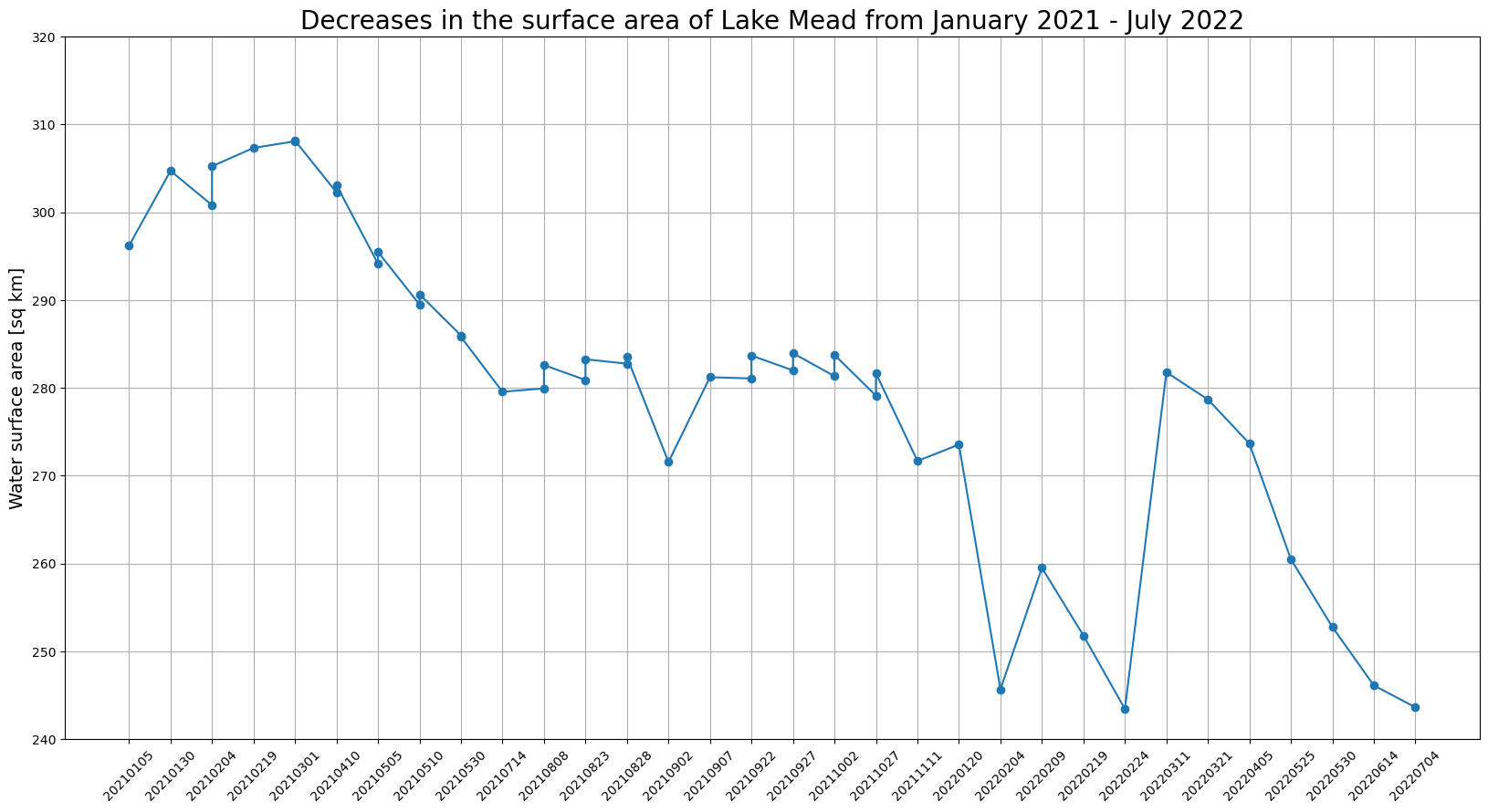
Untuk menghitung perubahan ketinggian air Danau Mead, unduh masker tutupan lahan ke instance SageMaker notebook lokal dan unduh gambar sumber dari kueri kami sebelumnya. Dalam peta kelas untuk model segmentasi tanah, indeks kelas air adalah 6.
Untuk mengekstrak masker air dari Sentinel-2 gambar, ikuti langkah-langkah ini. Pertama, hitung jumlah piksel yang ditandai sebagai air (indeks kelas 6) pada gambar. Kedua, kalikan hitungan dengan area yang dicakup setiap piksel. Band dapat berbeda dalam resolusi spasialnya. Untuk model segmentasi tutupan lahan, semua pita diambil sampelnya ke resolusi spasial sebesar 60 meter.
import os
from glob import glob
import cv2
import numpy as np
import tifffile
import matplotlib.pyplot as plt
from urllib.parse import urlparse
from botocore import UNSIGNED
from botocore.config import Config

# Download land cover masks
mask_dir = "./masks/lake_mead"
os.makedirs(mask_dir, exist_ok=True)
image_paths = []
for s3_object in s3_bucket.objects.filter(Prefix=prefix).all():
    path, filename = os.path.split(s3_object.key)
    if "output" in path:
        mask_name = mask_dir + "/" + filename
        s3_bucket.download_file(s3_object.key, mask_name)
        print("Downloaded mask: " + mask_name)

# Download source images for visualization
for tci_url in tci_urls:
    url_parts = urlparse(tci_url)
    img_id = url_parts.path.split("/")[-2]
    tci_download_path = image_dir + "/" + img_id + "_TCI.tif"
    cogs_bucket = session.resource(
        "s3", config=Config(signature_version=UNSIGNED, region_name="us-west-2")
    ).Bucket(url_parts.hostname.split(".")[0])
    cogs_bucket.download_file(url_parts.path[1:], tci_download_path)
    print("Downloaded image: " + img_id)

print("Downloads complete.")

image_files = glob("images/lake_mead/*.tif")
mask_files = glob("masks/lake_mead/*.tif")
image_files.sort(key=lambda x: x.split("SQA_")[1])
mask_files.sort(key=lambda x: x.split("SQA_")[1])
overlay_dir = "./masks/lake_mead_overlay"
os.makedirs(overlay_dir, exist_ok=True)
lake_areas = []
mask_dates = []

for image_file, mask_file in zip(image_files, mask_files):
    image_id = image_file.split("/")[-1].split("_TCI")[0]
    mask_id = mask_file.split("/")[-1].split(".tif")[0]
    mask_date = mask_id.split("_")[2]
    mask_dates.append(mask_date)
    assert image_id == mask_id
    image = tifffile.imread(image_file)
    image_ds = cv2.resize(image, (1830, 1830), interpolation=cv2.INTER_LINEAR)
    mask = tifffile.imread(mask_file)
    water_mask = np.isin(mask, [6]).astype(np.uint8)  # water has a class index 6
    lake_mask = water_mask[1000:, :1100]
    lake_area = lake_mask.sum() * 60 * 60 / (1000 * 1000)  # calculate the surface area
    lake_areas.append(lake_area)
    contour, _ = cv2.findContours(water_mask, cv2.RETR_TREE, cv2.CHAIN_APPROX_SIMPLE)
    combined = cv2.drawContours(image_ds, contour, -1, (255, 0, 0), 4)
    lake_crop = combined[1000:, :1100]
    cv2.putText(lake_crop, f"{mask_date}", (10,50), cv2.FONT_HERSHEY_SIMPLEX, 1.5, (0, 0, 0), 3, cv2.LINE_AA)
    cv2.putText(lake_crop, f"{lake_area} [sq km]", (10,100), cv2.FONT_HERSHEY_SIMPLEX, 1.5, (0, 0, 0), 3, cv2.LINE_AA)
    overlay_file = overlay_dir + '/' + mask_date + '.png'
    cv2.imwrite(overlay_file, cv2.cvtColor(lake_crop, cv2.COLOR_RGB2BGR))

# Plot water surface area vs. time.
plt.figure(figsize=(20,10))
plt.title('Lake Mead surface area for the 2021.02 - 2022.07 period.', fontsize=20)
plt.xticks(rotation=45)
plt.ylabel('Water surface area [sq km]', fontsize=14)
plt.plot(mask_dates, lake_areas, marker='o')
plt.grid('on')
plt.ylim(240, 320)
for i, v in enumerate(lake_areas):
    plt.text(i, v+2, "%d" %v, ha='center')
plt.show()
Dengan menggunakanmatplotlib, Anda dapat memvisualisasikan hasilnya dengan grafik. Grafik menunjukkan bahwa luas permukaan Danau Mead menurun dari Januari 2021—Juli 2022.