Terjemahan disediakan oleh mesin penerjemah. Jika konten terjemahan yang diberikan bertentangan dengan versi bahasa Inggris aslinya, utamakan versi bahasa Inggris.
Cara menambahkan poligon ke peta statis
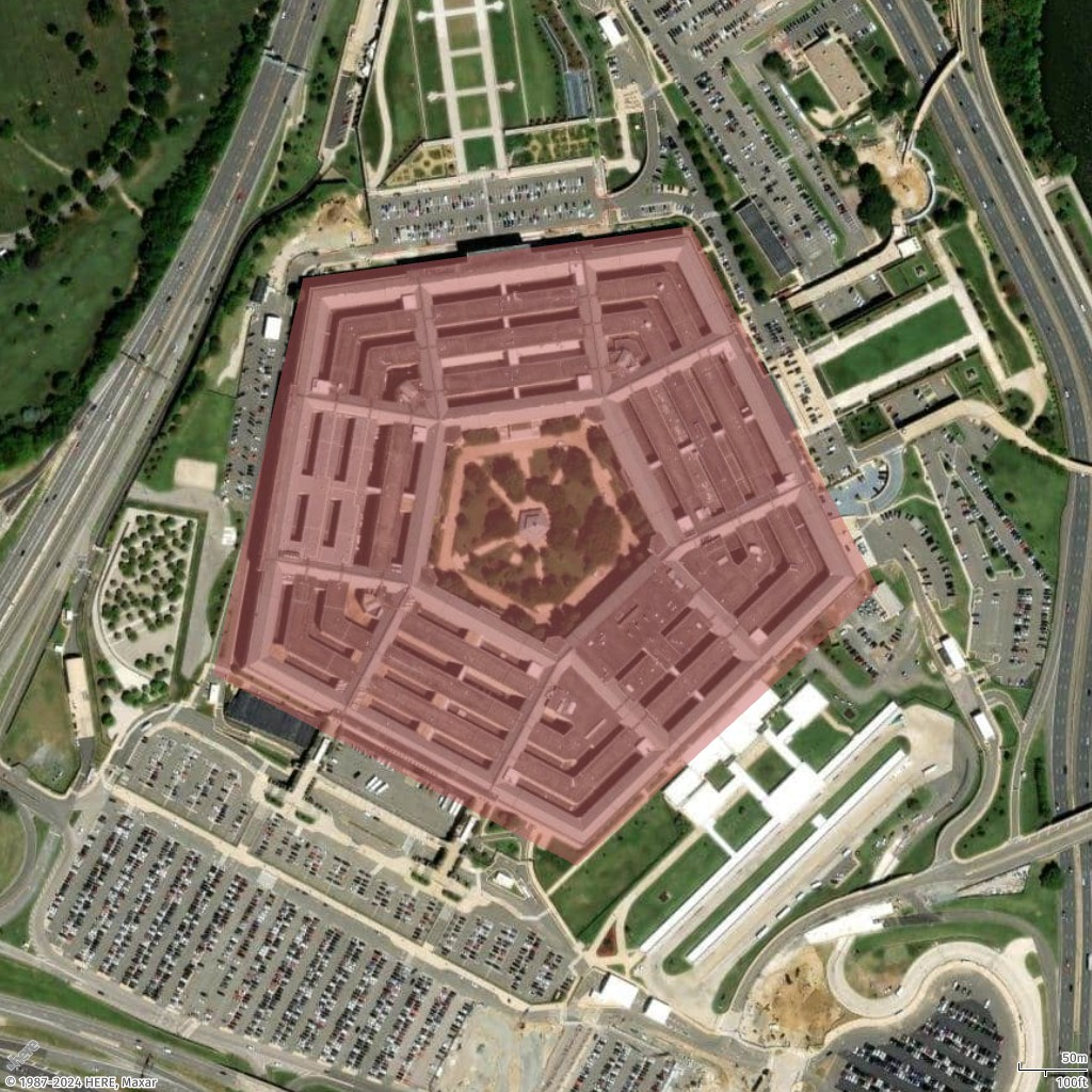
Bangunan dan lokasi dapat disorot pada peta dengan menunjuk poligon di sekitarnya, misalnya, Pentagon (terletak di Washington, D.C.).
Tambahkan satu poligon
Dalam contoh ini, Anda menambahkan poligon (pentagon) untuk bangunan Pentagon di peta.
- Geo JSON
-
{
  "type": "FeatureCollection",
  "features": [
    {
      "type": "Feature",
      "geometry": {
        "coordinates": [
          [
            [
              -77.0579282196337,
              38.87264268371487
            ],
            [
              -77.05868880963534,
              38.87003145971428
            ],
            [
              -77.05560979468949,
              38.86876862025221
            ],
            [
              -77.05305311263672,
              38.87059509268525
            ],
            [
              -77.0546384387842,
              38.872985132206225
            ],
            [
              -77.0579282196337,
              38.87264268371487
            ]
          ]
        ],
        "type": "Polygon"
      }
    }
  ]
}
- Request URL
-
https://maps.geo.eu-central-1.amazonaws.com/v2/static/map?style=Satellite&width=600&height=1024&padding=200&scale-unit=KilometersMiles&geojson-overlay=%7B%22type%22%3A%22FeatureCollection%22,%22features%22%3A%5B%7B%22type%22%3A%22Feature%22,%22geometry%22%3A%7B%22coordinates%22%3A%5B%5B%5B-77.0579282196337,38.87264268371487%5D,%5B-77.05868880963534,38.87003145971428%5D,%5B-77.05560979468949,38.86876862025221%5D,%5B-77.05305311263672,38.87059509268525%5D,%5B-77.0546384387842,38.872985132206225%5D,%5B-77.0579282196337,38.87264268371487%5D%5D%5D,%22type%22%3A%22Polygon%22%7D%7D%5D%7D&key=your_API_Key
- Response image
-
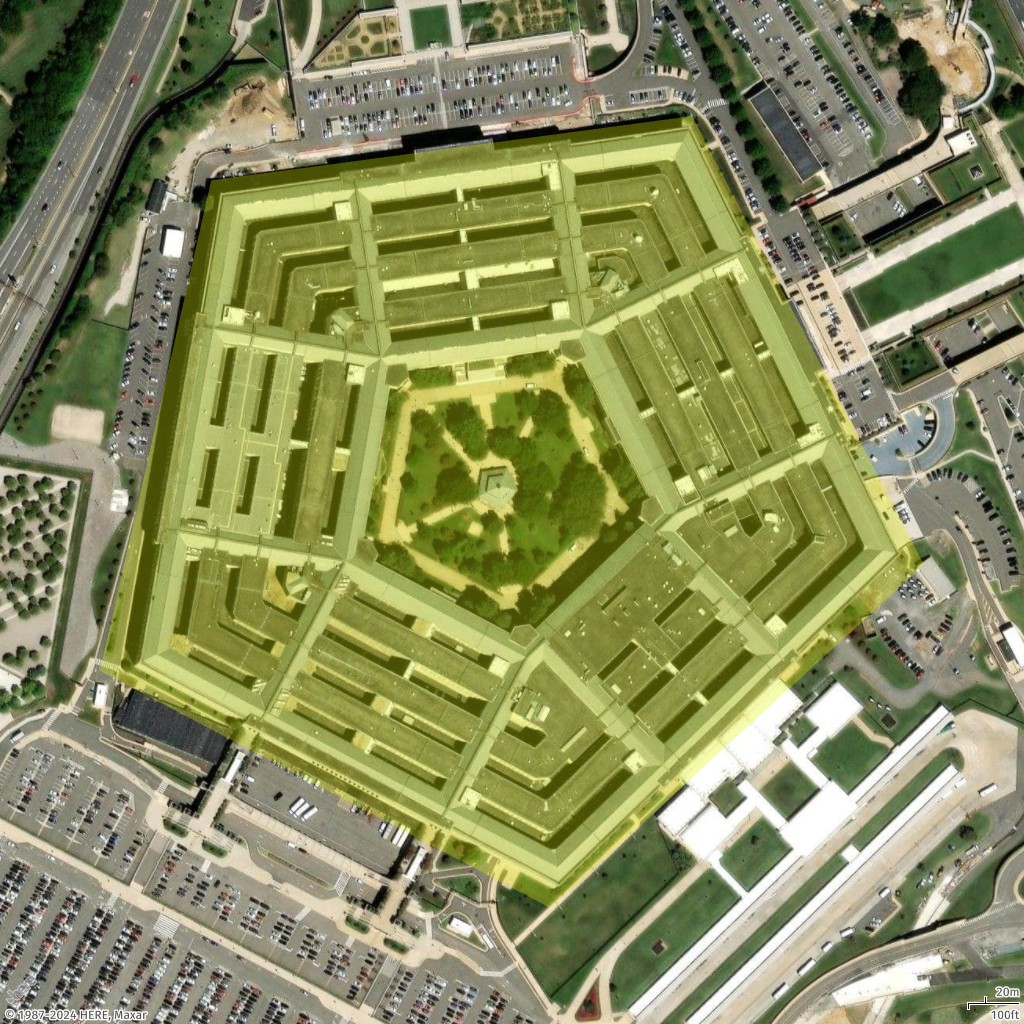
Tambahkan poligon gaya
Dalam contoh ini, kita menata ulang poligon yang ditunjukkan pada contoh sebelumnya. Kami menggambar poligon dalam warna yang berbeda (#E3F70550). Komponen warna adalah sebagai berikut.
-
E3 mewakili komponen merah.
-
F7 mewakili komponen hijau.
-
05 mewakili komponen biru.
-
50 mewakili komponen alpha (opacity).
- Geo JSON
-
{
  "type": "FeatureCollection",
  "features": [
    {
      "type": "Feature",
      "geometry": {
        "coordinates": [
          [
            [
              -77.0579282196337,
              38.87264268371487
            ],
            [
              -77.05868880963534,
              38.87003145971428
            ],
            [
              -77.05560979468949,
              38.86876862025221
            ],
            [
              -77.05305311263672,
              38.87059509268525
            ],
            [
              -77.0546384387842,
              38.872985132206225
            ],
            [
              -77.0579282196337,
              38.87264268371487
            ]
          ]
        ],
        "type": "Polygon"
      },
      "properties": {
        "color": "#E3F70550"
      }
    }
  ]
}
- Request URL
-
https://maps.geo.eu-central-1.amazonaws.com/v2/static/map?style=Satellite&width=1024&height=1024&padding=100&scale-unit=KilometersMiles&geojson-overlay=%7B%22type%22%3A%22FeatureCollection%22,%22features%22%3A%5B%7B%22type%22%3A%22Feature%22,%22geometry%22%3A%7B%22coordinates%22%3A%5B%5B%5B-77.0579282196337,38.87264268371487%5D,%5B-77.05868880963534,38.87003145971428%5D,%5B-77.05560979468949,38.86876862025221%5D,%5B-77.05305311263672,38.87059509268525%5D,%5B-77.0546384387842,38.872985132206225%5D,%5B-77.0579282196337,38.87264268371487%5D%5D%5D,%22type%22%3A%22Polygon%22%7D,%22properties%22%3A%7B%22color%22%3A%22%23E3F70550%22%7D%7D%5D%7D&key=your_API_Key
- Response image
-
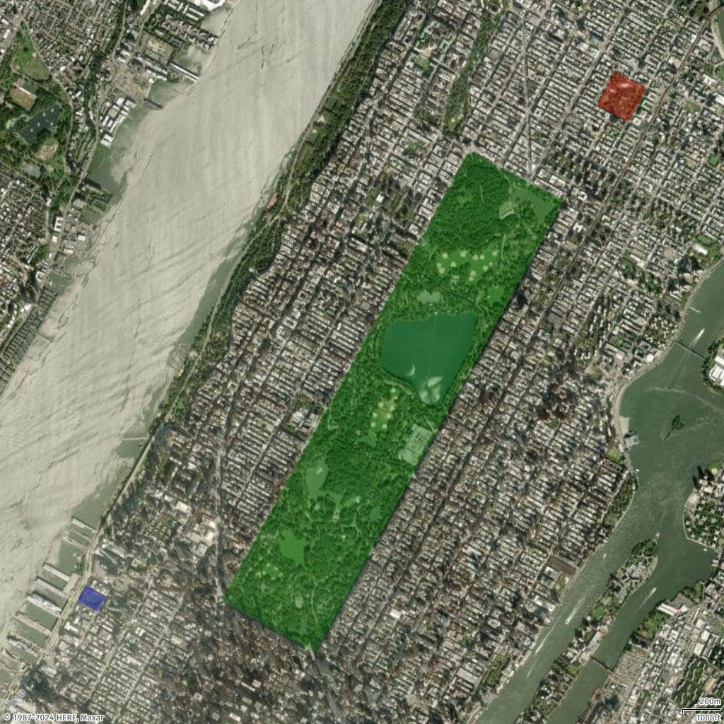
Tambahkan beberapa poligon
Dalam contoh ini, kami menambahkan beberapa poligon, untuk menyoroti beberapa taman di New York City.
- Geo JSON
-
{
  "type": "FeatureCollection",
  "features": [
    {
      "type": "Feature",
      "properties": {
        "color": "#00800050"
      },
      "geometry": {
        "type": "Polygon",
        "coordinates": [
          [
            [
              -73.95824708489555,
              40.80055774655358
            ],
            [
              -73.9818875523859,
              40.76810261850716
            ],
            [
              -73.9729556303776,
              40.7642422333698
            ],
            [
              -73.94916953372382,
              40.79699323614054
            ],
            [
              -73.95824708489555,
              40.80055774655358
            ]
          ]
        ]
      }
    },
    {
      "type": "Feature",
      "properties": {
        "color": "#FF000050"
      },
      "geometry": {
        "type": "Polygon",
        "coordinates": [
          [
            [
              -73.94432602794981,
              40.80634757577718
            ],
            [
              -73.94607200977896,
              40.803869579741644
            ],
            [
              -73.94301654157768,
              40.80263972513214
            ],
            [
              -73.94127055974795,
              40.805099411561145
            ],
            [
              -73.94432602794981,
              40.80634757577718
            ]
          ]
        ]
      }
    },
    {
      "type": "Feature",
      "properties": {
        "color": "#0000FF50"
      },
      "geometry": {
        "type": "Polygon",
        "coordinates": [
          [
            [
              -73.9947948382843,
              40.7691390468232
            ],
            [
              -73.99564708262241,
              40.76802192177411
            ],
            [
              -73.99372953286147,
              40.76723992306512
            ],
            [
              -73.99289367783732,
              40.76835706126087
            ],
            [
              -73.9947948382843,
              40.7691390468232
            ]
          ]
        ]
      }
    }
  ]
}
- Request URL
-
https://maps.geo.eu-central-1.amazonaws.com/v2/static/map?style=Satellite&width=1024&height=1024&padding=100&scale-unit=KilometersMiles&geojson-overlay=%7B%22type%22%3A%22FeatureCollection%22,%22features%22%3A%5B%7B%22type%22%3A%22Feature%22,%22properties%22%3A%7B%22color%22%3A%22%2300800050%22%7D,%22geometry%22%3A%7B%22type%22%3A%22Polygon%22,%22coordinates%22%3A%5B%5B%5B-73.95824708489555,40.80055774655358%5D,%5B-73.9818875523859,40.76810261850716%5D,%5B-73.9729556303776,40.7642422333698%5D,%5B-73.94916953372382,40.79699323614054%5D,%5B-73.95824708489555,40.80055774655358%5D%5D%5D%7D%7D,%7B%22type%22%3A%22Feature%22,%22properties%22%3A%7B%22color%22%3A%22%23FF000050%22%7D,%22geometry%22%3A%7B%22type%22%3A%22Polygon%22,%22coordinates%22%3A%5B%5B%5B-73.94432602794981,40.80634757577718%5D,%5B-73.94607200977896,40.803869579741644%5D,%5B-73.94301654157768,40.80263972513214%5D,%5B-73.94127055974795,40.805099411561145%5D,%5B-73.94432602794981,40.80634757577718%5D%5D%5D%7D%7D,%7B%22type%22%3A%22Feature%22,%22properties%22%3A%7B%22color%22%3A%22%230000FF50%22%7D,%22geometry%22%3A%7B%22type%22%3A%22Polygon%22,%22coordinates%22%3A%5B%5B%5B-73.9947948382843,40.7691390468232%5D,%5B-73.99564708262241,40.76802192177411%5D,%5B-73.99372953286147,40.76723992306512%5D,%5B-73.99289367783732,40.76835706126087%5D,%5B-73.9947948382843,40.7691390468232%5D%5D%5D%7D%7D%5D%7D&key=your_API_Key
- Response image
-